Southwest monsoon hits northern parts of Maharashtra
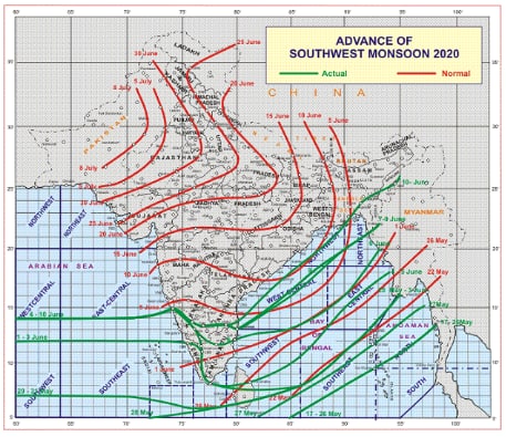
Even as the Southwest monsoon is moving towards South India at its own pace, it has hit northern parts of Maharashtra on Thursday.
Trending Photos
) Representational Image: ZeeNews
Representational Image: ZeeNews New Delhi: Even as the Southwest monsoon is moving towards South India at its own pace, it has hit northern parts of Maharashtra on Thursday. According to India Meteorological Department (IMD), the Southwest monsoon was predicted to hit northern parts of Maharashtra and Tamil Nadu.
"Monsoon has arrived in Maharashtra today. Conditions are favourable for further advancement in some more parts of the state, in the next 48 hours," said KS Hosalikar, Dy Director General, IMD Mumbai. "Heavy rainfall is expected in Marathwada and central Maharashtra in the next 4-5 days," he added.
It has also stated that conditions are likely to become favorable subsequently for further advance of Southwest Monsoon into some more parts of Maharashtra; remaining parts of Karnataka, Telangana, Rayalaseema, Coastal Andhra Pradesh, Bay of Bengal and northeastern states, entire Sikkim and some parts of Odisha and West Bengal during subsequent 24 hours.
"Conditions are becoming favourable for further advance of Southwest monsoon into some more parts of Central Arabian Sea, Goa; some parts of Maharashtra; some more parts of Karnataka and Rayalaseema; some parts of Telangana and Coastal Andhra Pradesh; some more parts of Central and North Bay of Bengal and some more parts of Northeastern states during next 48 hours," the IMD statement had said on Wednesday.
Heavy rains have been predicted in many districts of Maharashtra, Odisha and Madhya Pradesh during this time. Notably, several states including Delhi, Rajasthan, Madhya Pradesh are getting intermittent rains due to pre-monsoon activities.
It further stated that the SW Monsoon advanced into the remaining parts of Tamil Nadu, some more parts of west-central and north Bay of Bengal, adding that most parts of Mizoram and Manipur and Tripura and some parts of Assam and Nagaland.
The low-pressure area over East-central and adjoining Westcentral Bay of Bengal persists. The associated cyclonic circulation extending up to mid-tropospheric levels tilting southwestwards with height also persists. It is likely to move west-northwestwards and become well marked during the next 24 hours.
Stay informed on all the latest news, real-time breaking news updates, and follow all the important headlines in india news and world News on Zee News.
Live Tv


)
)
)
)
)
)
)
)
)
)
